Bharachukki falls is around 12kms from Gaganachukki falls. A small junction could be spotted just before Gaganachukki falls. One of them will lead to Bharachukki falls. Take help of guards if you get confused. The road will lead you to NH-209 and after few kms of travel, you need to deviate further to interior road. The ride was really fabulous en-route. What a beauty! Water Water everywhere. The overflowing lake water to the main road was bit scary though :D. The gushing water at distance, the beautiful channels, the green hills and of-course gorgeous rural landscape filled my soul with glory. It was really worth such long bike ride. Along NH-209 I encountered a narrow bridge where Cauvery was just below the bridge level. There was tremendous gravity pull too :-). Had to be really careful since slight tilt would end up in accident due to narrow roads. Sometimes I felt, would really fall out of bridge :D. I stopped nearby bridge and took some photos. The bridge is so narrow that two heavy vehicles cannot cross over simultaneously. Since traffic flow was less, there was no scope for jams.
CHANNEL ENROUTE
OVERFLOWING CHANNEL WATER ENTERING MAIN ROAD
ONE MORE CHANNEL!
NARROW BRIDGE ACROSS NH-209
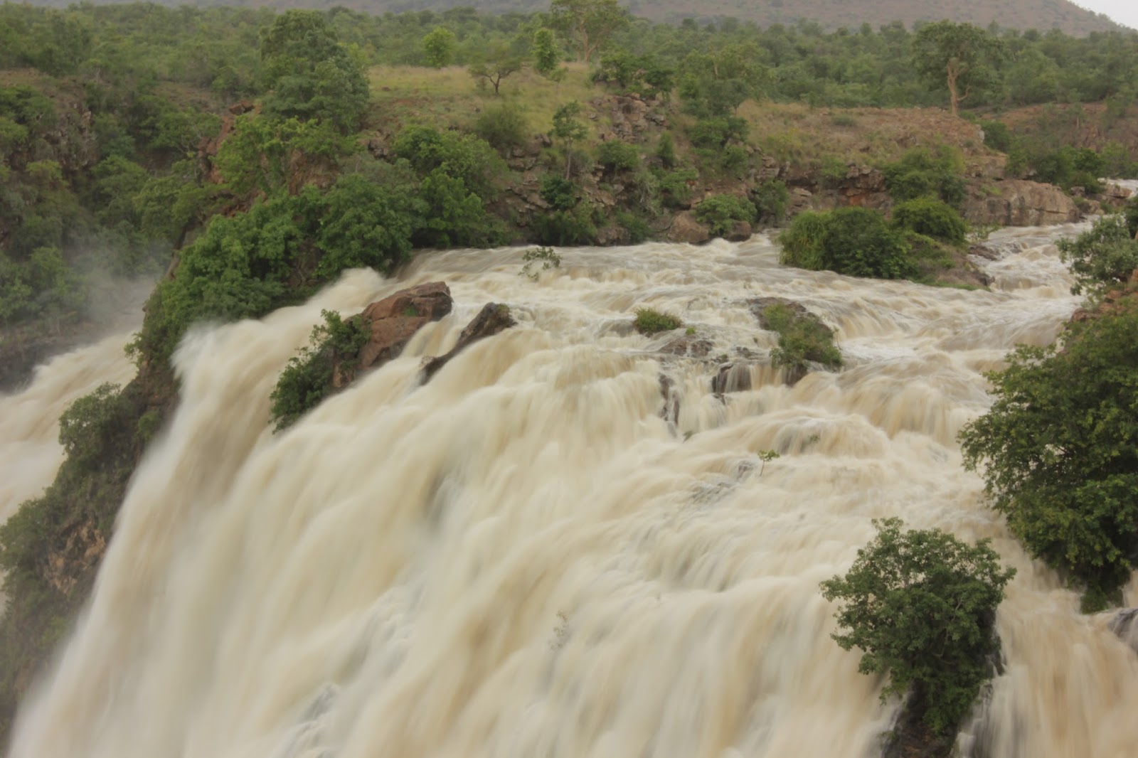
Few kms later, a junction directs you to Bharachukki falls. From here, the sight is around 6kms. There is one more narrow bridge enroute. There was traffic jam here due to flurry of tourist vehicles. Nearby the bridge, torrent of Cauvery attracted me. I parked the bike in vacant area and stepped on the bridge beneath. There was huge water gush and heavy breeze too! OMG that was great sight to watch and scary too :-). After relaxing at this spot, I resumed my bike journey. By that time, the traffic also got cleared. There are few temples on the way to Bharachukki falls. An entrance fee of Rs.10/- is levied again on two wheelers. Similar to the earlier one, the roaring sound of waterfalls could be heard even from distance. There was huge crowd here too! This was bit wider also. Now time to energize soul for second time ;-). I do not know the geometry behind these two falls. Some where they divide and consequently flow along different paths. Bharachukki spot has around 300 steps to go down to falls. However it was closed due to huge torrents. They would re-open the steps when conditions become favorable to allow. I have same feelings as felt in Gaganachukki falls. Absolutely gorgeous nature. I took videos at different angles and also snaps. At times I wish, I had a wide angle lens ;-). Landscapes are so much enchanting to shoot :-).
CAUVERY RIVER FULL SHOW OFF ;-)
VIEW OF TORRENT FROM NARROW BRIDGE
BHARACHUKKI WATERFALLS
FULL VIEW :-)
VIEW++
ONE MORE FULL VIEW!
CLOSEUP LOOK
WATER FLOW AFTER PLUNGE
READY TO PLUNGE!
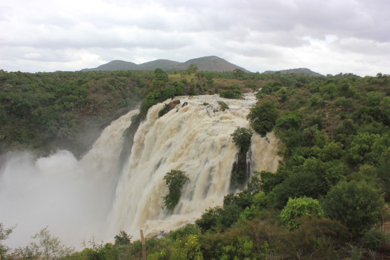
I had two full cucumbers to satisfy physical thirst. When I was about to leave, I could see the distant view point from falls. I again parked the bike aside and stepped to the top of the platform. What a majestic sight to capture the beauty of water falls! Absolutely eye-catching view! From here 18mm is far enough; wide angle was not required ;-). I had one more photo-shoot here too ;-). This time I could not shoot milky ways due to presence of SUN. The photos were overexposed even at around f/36. ND filter was must.
FULL VIEW OF BHARACHUKKI FALLS
After some more time of stay, I started journey towards Talakaadu. You need to return along the same route to reach Talakaadu. After the narrow bridge along NH-209 as mentioned earlier, there is a deviation with crisp and clear signboard to reach Talakaadu. Talakaadu is around 23kms from this cross. The road is absolutely marvelous. No problem at all in maintaining 60kmph. Also very few humps nearby village limits. I enjoyed the ride as well as the beautiful rural landscape with monsoon clouds. The scenery along this route is absolutely stunning. Due to lack of time, I could not take photos enroute but they were simply eye-catching. Few kms after, there is left deviation towards Talakaadu. But one of local immediately stopped me and asked me to take an alternative route. This path is submerged under water due to too much water being let out. I thanked them before proceeding along alternate route. Few kms further, one more deviation towards will lead you to Talakaadu. From here, it is around 9kms. This stretch has landscapes beating the other stretches mentioned earlier. Especially once you near Talakaadu, the sight of Cauvery river flow is beautiful to watch. Also there was storm building at horizon which would have been one more great timelapse. However due to lack of time, I skipped the spot :(. Around 4PM, I reached Talakaadu. The main attraction here is Panchalinga Darshana which is 5 shiva temples. Panchalinga Darshana happens for every 12 years and the last time it happened was on 2006. There will be huge gathering at this time. Read wikipedia entry to know exact details. At this time, the poojas happen at a time in all the 5 temples. During my visit, I could get only 3 (Vaidyanaatheshwara, Maraleshwara, Pataaleshwara). I missed the other two may be since I was in a hurry (Arakeshwara and Mallikarjuneshwara). The vaidyanaatheshwara temple is made from stones and surroundings are very well maintained. The deity was very well decorated too! It is believed that people take bath in cauvery water and visit this temple to heal their diseases. Not so many people were seen at this place. Later I walked along sand path to visit few more temples. Mainly I noticed Maraleshwara (The eeshwara temple on sand?), Paataaleshwara and chowdeshwari temples. It took almost an hour to visit all of them. Slowly hunger started haunting me. I had lunch in one of the mess. The meals was not so good but enough to get rid of hunger. There is also Udupi mess near by vaidyanaatha temple but meals were closed here. It is run by Udupi people itself (they speak my language which is Tulu).
VIEW OF VAIDYANATHESHWARA TEMPLE
FRONT VIEW
At around 5PM, I left to view Cauvery river basin nearby. There was nothing much to see here except the river water had overflown. You can also have ride on coracle for short distance and they charge Rs.20/-. Due to lack of time I skipped that too! I also dropped plans of visiting Somanathapura :( Next time I will dedicate more time for Talakaadu and Somanathapura to enjoy beautiful architecture :-).
CAUVERY RIVER AT TALAKAADU
It was 5:30PM when I started my return journey towards Bangalore. After traveling for few distance, thick clouds gathered around the place and started pouring. That was really thick drops. I took shelter in an under construction temple for 30minutes before rains could recede. I enjoyed those beautiful rain droplets. Even though this site is common in my hometown, I believe there is uniqueness in rains of each and every place. Around 6PM I resumed my journey. I enjoyed the beautiful landscapes again. There is an inner-route to reach Malavalli which eventually joins NH-209.
30 minutes later, I reached Malavalli. This time I gave try to travel along Kankapura road instead of busy four lane highway. So I had to drop plans of visiting Kanva reservoir which would have been impossible even if I had taken four lane route due to lack of time. What a surprise! the road is really fantastic and perfectly even ;-). This road is far better than Maddur one. No humps, beautiful landscapes, hills and less traffic too! I felt, should have chosen this route. Barring few potholes, the road is absolutely smooth. Only problem in this route is feeble food outlets and also crossing cattle :D. I was bit speeding in this section around 70-80kmph to reach as near to city as possible to city before twilight. If you are experienced driver, you know the apathy of riding/driving during those hours. Everything seems invisible and high beams of HTVs add to the horror story! Around 7:00PM I was almost 20kms behind city. Thereafter, no question of speeding due to high beamers. Had to really cut down speed to 40-50kmph. It was around 7:30PM when I reached city limits. Heavy rains started pouring and it was difficult to ride too. Also bad roads added more trouble. Once bad roads start, you know you are in city limits. Not sure why corporation repairs roads during rainy days rather than drier one. Leave that apart, meanwhile I was fully drenched in rain. I enjoyed it to maximum. 9:10PM sharp, I reached home due to hectic traffic jams. Since camera bag had raincoat and I had jacket, no damages happened barring wet jeans and shoes.
Thats end of what I call my tiny adventure (This was kind of for me). So many memories :). Those plunging water, beautiful landscapes, gushing water, smooth roads and lovely locals filled my eyes and heart. Especially I cannot forget lovely local people who helped and guided so much in right way at many places. Not to miss tasty cucumbers and sugar cane juices too! As guessed earlier, I could spot many lone riders like me but did not talk to anyone though.
When to visit:
1) If you wish to see full glory, watch out for news reports on KRS reservoir status. This will be usually around July-September time frame. 2) If you wish to enjoy excursion nearby waterfalls, visit post monsoon season when rain recedes and inflow decreases. Which route:
As of now, I highly recommend Kanakapura road. If you have sufficient food packed, please take this route. Mysore road is full of humps and nasty traffic.
Whats up this time!
1) A HDR of Gaganachukki falls which is documented here: Gaganachukki in HDR
2) I wanted to shoot timelapses of one of the falls with cloudy backdrop as well as storm rising nearby Talakaadu. Due to dearth of time, I could not capture even a single timelapse. I wish to travel again post monsoon which I believe will be able to capture some if there are clouds!
3) Here is a compilation of videos of the visit
Hope you enjoyed the lengthy 2 part blog :-). Your critiques on content, grammatical approach and pictures are highly appreciated and welcome.
Edit1
I forgot to mention some details. The Gaganachukki waterfalls has two view points. One is 12kms from Bharachukki falls and another is nearby Bharachukki falls itself. The one 12kms away is main view point. The nearby view point is also good which gives closeup look of gushing water. Due to time constraints, I did not visit the other view point.
Edit 2
Recently when I traveled again along this route, I had lunch in Vasu Hotel situated in Kanakapura main town. They serve delicious vegetarian south Indian food for very less price. The variety is very minimal however whatever they serve is really good. It seems to be one of the old hotels of Kanakapura (had antique look like MTR, Bangalore).
Pretty lengthy write-up. May conclude in one or two more parts. Not a mega serial but lengthy travelogue ;-).
It has been raining very heavily in Malnad regions from quite sometime. Almost everyday, Bhagamandala is receiving more than 10cms of rainfall. 2days back, it was whopping 25cms. When it rains heavily in catchment areas, reservoirs regain their glory and waterfalls come alive again. I wanted to enjoy waterfall landscape after reading news reports (I read only monsoon reports in newspaper and nothing much). Thought of visiting Jog however it is too far from Bangalore and requires planning. If I commute from hometown to Jog it is hardly 4hrs. Consequently dropped the plan of visiting Jog. Next, what would you imagine when 1.5lakh cusecs of water is let out of KRS Dam? Yes it's Shivanasamudra falls which is 120kms from Bangalore! OK thats fair enough and reachable in a day but how? Public transports are not present to this place. Only option was bike but it was 120kms. I thought of giving it a try! This time my team mates had personal work so I was left alone. I have many experiences of traveling alone and this one is no different. Only difference was I was riding bike for such long distance for first time. Never lose enthusiasm even if you travel alone, who knows you may find lone travelers like you and have nice gathering :-).
Finally I decided to ride my Honda Shine (which I call Airavat) all the way to Shivanasamudra falls :-). It was serviced just a day before travel with brand new break shoes, engine oil and of-course Teflon coating ;-). The bike was really shining and energetic too! Got up early around 4:30AM, prepared wheat flour doses(3), prayed god and started my journey. I had cleared 32GB SD card and charged both batteries fully too! Finally not to forget water and food packets which are very much essential for me. Long ride/drive makes you very hungry which I have experienced while driving car for long distance. Also weather guards are very much necessary (like jerkin, umbrella etc..).
There are two routes; one via Kanakapura and other via Maddur. Both lead to Malavalli which is junction and both routes are equiv-distant. I decided to take the Maddur route since it is 4-laned highway. My journey started around 7:45AM and what a surprise! The city road had already come alive. The roads were clogged with vehicles and lengthy signals delayed reaching Mysore road early. It was frustrating to hear honking vehicles at the back wanting to break signals. I decided to take NICE road to avoid further congestion. The toll for bike is Rs.22/- from PESIT college to Kengeri. Immediately after reaching the Mysore State highway, there was pathetic traffic jam nearby Bidadi. A long truck had broken down in middle of highway and vehicles were struggling to get through it. That added almost 30minutes of delay again :-(. Vehicles were seen lined up for few kms. Also the desperate drivers wanting to get through the heck early added more fury by traveling in opposite lane which clogged the roads at both ends. It would have added some more delay if the vehicle was four wheeler. After so much obstacles, the journey started to get smooth. I was maintaining steady speed of 50-60kmph to gain control of vehicle. The rushing people, sneaking vehicles, wrong siders (especially bullock cart) and of-course recklessly laid unscientific humps make it miserable to travel with good speed. The sudden turning of tractors without indication was really horrible. I guess we can call this Highway as Humpway. So many humps especially at Channapattana.
NICE ROAD
BANGALORE-MYSORE STATE HIGHWAY
Enough of cribbing ;-). Despite of poor start, it was delightful to watch the wooden toys in Channapattana. Also I observed signboards of Kanva reservoir just before Channapattana which I noted to visit during return journey. I reached Kamat Upahar near Maddur at around 10:30AM which is 3hrs tight for mere 80kms :(. Even though I had breakfast at home, I was very hungry. As mentioned earlier, long drives lead to too much hunger if you are rider/driver. I had hefty breakfast again :D. The breakfast was delicious and tasty with little bit more cost. They provided Moode Idli [Udupi special ;-)] which was very good. Few minutes after having breakfast, I reached Maddur. After Maddur town, you can find a junction which leads to Malavalli. From Maddur, Shivanasamudra is around 44kms. The signboards are properly laid. I was very much relieved after entering the interior roads since there was very feeble traffic. Unfortunately the roads are only patched and not even. However, few sections were really good with fantastic pavements. Anyhow it was only 20 odd kms. From Maddur to Malavalli the road is State Highway and expect humps. From Malavalli to Shivanasamudra cross, it is NH-209 which runs via Kanakapura. From Malavalli, the road is absolutely gorgeous with less traffic. I could easily ride my bike without any hesitation. Good thing about National Highways is no humps. It is not possible to unscientifically lay a hump in National Highway. Unless it is truly necessary (like toll booths, steep curves), one can safely assume hump free roads. Only problem is cattle crossing and crazy dogs. NH-209 is beautifully re-surfaced and straight enough too! Enjoy the beautiful rural landscape all along!
THE BEAUTIFUL NH-209
LOVELY LANDSCAPE ALONG NH-209
STRAIGHT VIEW :-)
ONE MORE HILL VIEW
From Malavalli, Shivanasamudra is around 18kms. There is hiding signboard where travelers have to take deviation to reach Gaganachukki falls. From NH-209 deviation, the falls site is around 4kms distant. After traveling along interior roads for few kms, you will notice signboard near by channel directing to right. The signboard is in Kannada and hence ask guards nearby area for directions if you cannot read it. The guards seem to be employees of power station located in Shivanasamudra.
Around 12PM, I reached the wonderful site. Despite of huge crowd, I could hear the roaring Gaganachukki falls from distance. The gushing water could be seen from a distance itself and the excitement increased as I neared the majestic waterfall. What a sight to watch :-). Absolutely wonderful nature. It is really amazing to see how monsoon season transforms parched lands into ultimate beauty. As expected, everyone was adamant to photograph this gorgeous site at varied angles. Even I took lot of videos and images too ;-). One can have good view of water falls from the view point by stepping down. However it was difficult to grab some space since the sight was heavily crowded. Everyone was thrilled to take self-portraits along with water falls :-) (I also took mine with help of visitors!). Somehow managed space for myself and did not give-up until I took some snaps closeup! After having taken so many pictures with full circus, I returned to main area and had 2 full glasses of tasty Sugarcane juice with lemon mix. Many people had DSLRs so I was no different. In fact a visitor was trying a long exposure with ND3 and a canon L lens :D. When enquired, he said ND3 was bought in UK for 300 pounds (I was about to faint!).
THE FIRST VIEW OF GAGANACHUKKI FALLS
ONE MORE VIEW
THE CLOSE-UP KESAR MILKY WAY ;-)
SIDE VIEW
THE TORRENT
CROSS-SECTION VIEW
DISTANT MILKY WAY :-)
Not much monkeys here. This monkey snatched food from one of the visitors and enjoyed atop of tree :)
HA HA GOT IT!
GARDEN
GUSHING WATER READY TO PLUNGE!
There is Mayura shop and restaurant nearby area but not many people were seen having food here. There is nominal fee of Rs10/- for two-wheeler parking. The sight of waterfall energized my soul. Now it is time to move towards Bharachukki falls.
Coastal Karnataka barely has any winter season (relatively). People will laugh at you if they see winter wear. There is no restricted season where you cannot have ice-creams. Throughout the year people enjoy ice creams very much. Many prominent ice-cream makers are from coastal Karnataka like Ideal and Nature. Among the ice cream varieties, prominent is the legacy and evergreen gadbad ice-cream. Gadbad in Konkani means 'erroneous'. It was started by the owner of Ideal ice-cream chain in Mangalore. It is believed that ice-cream was prepared without any idea and hence the name :-). Ideal ice cream also has the largest ice cream parlor in India housing around 300 visitors. Whenever I get an opportunity, I do visit Ideal ice cream parlor just to relish gadbad ice-cream :D. Nowadays they serve many varieties other than Gadbad. In Udupi, you can get good one in relocated and newly built Diana restaurant situated near Taluk office. Both of the restaurants serve tasty, soft and pure vegetarian gadbad ice cream. The picture was taken during our visit to Diana restaurant around beginning of June just to have the ice cream. Don't miss the delicious treat if you visit either Mangalore or Udupi.
By the time I took the photo, it had already started melting. It was so much humid on that monsoon day. My father started making fun of me too that I will have Gadbad milk rather than ice cream :-).
This is 3 exposure bracketed HDR of Gaganachukki falls. The shots were taken during my solo bike ride to Shivanasamudra and Talakaadu on 03-Aug. I had taken 5 shots however it did not come out so well and hence limited final composition to 3 bracketed shots in Luminance HDR. There was huge crowd as expected and bracketing steady shots was difficult. I found a wall along the steps where I could place the camera to compose bracketed shots without any mis-alignment.
Even with 3 bracketed shots there were slight problems. At the edges of the hills there were fringing which could be noticed only after thorough investigation. For normal viewers, it may not be noticeable but people in landscape photography forums do notice such fine details. I was really annoyed seeing it. Eventually I wanted to correct it by some means. First I gave a try reducing chromatic aberration tool in GIMP which did not work out (or I did not use it properly?). The next option was to select the damaged part of image and reduce saturation values for those colors. The major dis-tractors were cyan and red. I chose Hue-Saturation tool and selected cyan and red and teared down the value to -100%. Bingo! all fringes are gone :-). I was really excited after seeing the result. Hope you will enjoy the image too! One more thing I learned was to bracket only 3 shots for HDR during broad daylight. I believe more bracketing is required only during magic hours. Please let me know if you have any alternate opinions.
So why do I struggle so much for HDR? As mentioned in earlier blogs, the natural world looks so beautiful in HDR. Our eyes have greater dynamic range while cameras do not have. The cameras which do have are highly expensive. Hence this sort of circus is required ;-). Once again I did the same mistake, not shooting RAW. I don't know when will I correct myself.
GAGANACHUKKI FALLS
Settings:
Camera: Canon EOS 550D Lens: 18-55mm kit lens Focal Length: 18mm Focus: Manual Aperture: f/22 (of-course to get vast depth of field) ISO: 100 Picture Style: Neutral (Thought of increasing sharpness later) Metering: Center weighted average No of images: 3 (initally 5) Exposures: -2,0,+2 (initially -2.-1,0,+1,+2) (1/30s for middle one) ML Firmware: v2.3 Softwares: Luminance HDR (Fatal operator), GIMP
It was all pre-planned this weekend for maiden visit to Shravanabelagola which is around 120kms from Bangalore. There were lot plans earlier which could not be materialized due to invalid reasons. This time I was persistent enough to travel to Shravanabelagola and that materialized too!
The plan was to start early as 8AM since people in Internet mentioned that it would taken an hour to reach top of hill. This time we delayed by 2 hrs i.e. we started around 10AM from majestic. Meanwhile we skipped bike journey since it was too long and public transport was ample. In majestic, we caught Karnataka Saarige (aka red bus) bus destined to Hassan. He started 10mins after gathering few passengers. The bus was relatively empty and we converted 3 seater to 2 seater ;-). We had feeling of entire bus was for us :D. The bus was speeding within town roads while jerking along four lane highways :-). They also halt for small tea break en-route and the shops nearby overprice everything. The bus also enters many towns en-route deviating from NH. Cumulatively this adds 20-30 mins overhead especially in Kunigal town.
It was around 1:00PM when we reached Hirisaave. When enquired with locals, they asked us to take an auto since buses are very rare. The auto is a mass transit system and waits until becomes jam packed. This is main source of transport even for locals who travel interiors. We sat at the back of auto rickshaw :). I felt nostalgic and remembered those days when we used to travel on similar lines. The travel to Shravanabelagola was fabulous with monsoon rain dripping from sky as well as beautiful rural landscape. There were majorly coconut and sugarcane fields with numerous buffaloes :D. Since we were sitting at the backside (having open sight), we could get good glimpse of the landscapes.
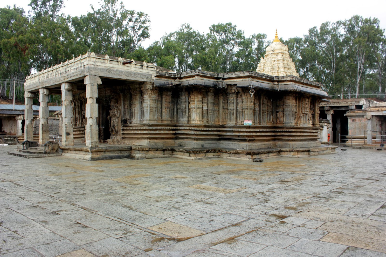
After nearly 40mins of auto journey here we are at Bahubali's place. Watching the Vindhyagiri hills, we could easily guess that it would take hardly 15mins to step. As mentioned in Internet, it does not take 45 minutes to step up the hills. We were relieved to see the simplicity of stepping since our presumption was based on Internet sources. Also our fear was that we would reach late on our return journey. The sight gave us big relief and decided to step after having lunch. We had nice lunch in one of South Indian veg restaurant. It costs 50/- for meals. There is a Jain hotel too, which people had good feedback about. Not sure since we did not eat at that place. I am not narrating mythology behind the construction of statue. There are plethora of articles in regard to this around Internet world. I am writing only travelogue of mine :-).
Relatively easy to step!
The overcast sky made our climbing more easy due to absence of SUN. One has to leave foot-wears before stepping towards the peak. The presence of scorching mid-day SUN would have burnt our toes since rocks heat up so intensely. Also littering of place and having eatables is prohibited. There seems to be around 500 steps to reach Bahubali's sanctum-sanatorium. Fortunately no monkeys here (may be because no eatables are allowed :D). We were stepping slowly to avoid side effects of having lunch just before start. Some people were seen taking the neighboring rocky surface to climb the hill rather than using steps. The sight of kid climbing on the rock surface was hearty to watch. He was angry when his father picked him up after sometime :D. After 20 mins of stepping, we reached the Bahubali's place. En-route, there are various Basadis with crisp and clear description both in Kannada and English. Also you can see the scriptures on rocks.
We are ready to STEP!
LANDSCAPE!
LOVELY AND ENTHUSIASTIC KID :-)
LANDSCAPE VIEW STILL MORE UP!
THE FIRST STAGE OF STEPPING IS OVER
SCRIPTURES
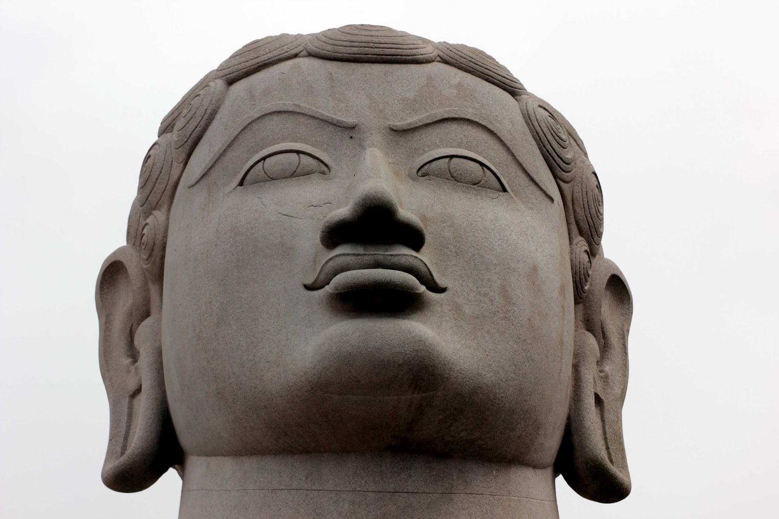
In 20mins we easily reached sanctum-sanatorium. What a sight to watch. I believe the statue was built under supervision of Chavundaraya for his mother. The temple is somewhat similar to Hindu temples with full of rocks being used. The surrounding of temple has statues of all 24 Jain teerthankaras. I also took some shots along the corridor behind the statue. One good thing here is photographers have full freedom ;-). You can shoot anywhere you wish without any objection. I grabbed as much as I could. Since it was Saturday, not many people were seen. We spent some time at temple premises enjoying the breeze and surroundings. I also kept camera in intervalometer mode for short timelapse.
LORD BAHUBALI
CORRIDOR BEHIND STATUE
LORD BAHUBALI'S FEET
THE FRONT END. EVERYBODY IS PHOTOGRAPHER :D
PROFOUND BAHUBALI
PILLARS
After spending few hours, we wandered around the temple outskirts. There were really delightful landscapes including the distant rains. The approaching distant rains would have been great for timelapse however I did not have tripod. The small pond beneath the hillock named Kalyani was magnificent to watch. As we were getting down, we saw kids climbing faster and with ease than elders :D. The kids can easily climb such hillocks. I remembered my 7year old nephew who climbs faster than us without any difficulty. There is also one more hillock named Chandragiri where a Chandragupta Basadi is located. Due to lack of time, we could not visit the place. Probably next time when we visit, we will first step in to Chandragiri
KALYANI FROM TOP OF HILLOCK
LAKE VIEW FROM TOP
We stepped down in matter of 10-15mins. It started raining as we reached foothills. We had come fully prepared and had individual umbrellas. Since it was raining, we decided to skip auto transport. The buses are present only for Channarayapattana and we took the bus despite being detour. CR Patna is around 13kms from Shravanabelagola. The landscape in this route is more beautiful than Hirisaave one. There were lot of Lotus on one of lakes but could not take any snap; only my eye enjoyed it. It was around 5PM when we reached CR Patna. We could get Bangalore immediately after alighting the local bus. The bus slowly started moving towards Bangalore. As we entered outskirts, I was delighted to see the completed construction of brand new Channarayanapattana bypass. They did construct it so rapidly! The Devihalli-Hassan section four laning was already delayed and cost escalation would have prompted them to execute the work quickly. Whatever may the reason, it's a good news! Saves again around 15mins for Mangalore travelers :-) [But to buy tasty cucumbers you have to enter town ;-)]. In middle of journey I had 20 mins power nap which was refresher. After that, it was time to enjoy beautiful landscape along NH-75. It was around 9:30PM when we reached Majestic due to hectic traffic jams. In the end, one more travel and one more blog :-).
AFTER RAIN EFFECT ;-)
How to reach:
If you are traveling by bus, catch Hassan bus at Majestic and alight at Hirisaave. From there you can catch autos which take you to Sharavanabelagola. Note that autos wait until they are jam packed. If you want to avoid autos, you need to travel 21km ahead and get down at CR Patna in same bus. From there, one can get frequent KSRTC buses to Shravanabelagola. The distance from Hirisaave to Sharavanabelagola is 18km while from CR patna 13kms. So effectively there is 16kms of overhead traveling via CR Patna. Also the total cost for former is 120+20 while the latter route is 135+13 which is Rs.8 more
If you are traveling by personal vehicle, Hirisaave is best option. The road from Hirisaave is in good condition with seldom damages however road from CR Patna is very good. You need to pay toll at 3 booths and one more is coming up near Hirisaave. So it will be 4 in few days. I am not familiar with any interior routes. The road till Hirisaave is fantastic. If you wish to travel via CR Patna, you need to travel along town road. Do not take the bypass. Watch out for the signboards just before town, which leads to Shravanabelagola.
When to visit:
During overcast days since scorching SUN will heat up rocks so intensely. For people who cannot step, there is manual lift facility available from base of hill. Not sure how much it would cost.
Whats up this time!
1) Did shoot a HDR of Bahubali but did not come out well. There were certain fringing at the edges. Tried to remove by decreasing saturation but in vain. It might have been because of hand-held bracketing which caused slight misalignment. Nevertheless, I turned it to Black & White :D and here is picture. The HDR looks are only felt in color picture but one can see clouds properly in image ;-).
MONOCHROME PICTURE
2) TimeLapse of clouds hovering behind Lord Bahubali. As said earlier, will club most of them into single one.